

Space WX Alerts:
( Latest Alert ) - Issue Time: 2024 Apr 26 2300 UTC
41.0°F
Light air
Updated:
4/27/24 2:50am
| Advisories / Alerts |
| Severe Wx Summary! | ||||||||
 |
||||||||
|
||||||||
|
||||||||
 |
||||||||
| Sat, Apr 27, 2024 - 2:41am | ||||||||
|
|
|
|
|
|
Info Links
Long Valley Volcano
|
Long Valley Update Unavailable Error reading Long Valley Update data. |
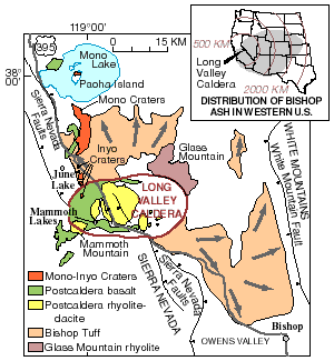 Much of the Long Valley area of eastern California is covered by rocks formed during volcanic eruptions in the past 2 million years. A cataclysmic eruption 760,000 years ago formed Long Valley Caldera and ejected flows of hot glowing ash, which cooled to form the Bishop Tuff. Wind-blown ash from that ancient eruption covered most of the Western United States (inset).
This massive eruption was followed by hundreds of smaller eruptions over the next few hundred thousand years. These eruptions of lava flows, domes, and pyroclastic flows were concentrated in the central and western parts of the caldera (green and yellow areas). Mammoth Mountain was built eruptions between about 200,000 and 50,000 years ago. Volcanic activity then moved northward to the Mono Lake area about 35,000 years ago to build the Mono Craters. The most recent eruptions in the area occurred from the Mono and Inyo Craters about 600 years ago, and from Negit Island in Mono Lake about 250 years ago. Much of the Long Valley area of eastern California is covered by rocks formed during volcanic eruptions in the past 2 million years. A cataclysmic eruption 760,000 years ago formed Long Valley Caldera and ejected flows of hot glowing ash, which cooled to form the Bishop Tuff. Wind-blown ash from that ancient eruption covered most of the Western United States (inset).
This massive eruption was followed by hundreds of smaller eruptions over the next few hundred thousand years. These eruptions of lava flows, domes, and pyroclastic flows were concentrated in the central and western parts of the caldera (green and yellow areas). Mammoth Mountain was built eruptions between about 200,000 and 50,000 years ago. Volcanic activity then moved northward to the Mono Lake area about 35,000 years ago to build the Mono Craters. The most recent eruptions in the area occurred from the Mono and Inyo Craters about 600 years ago, and from Negit Island in Mono Lake about 250 years ago. |
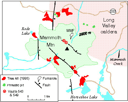 Map showing topographic outline of Mammoth Mountain along the southwestern edge of Long Valley Caldera, phreatic craters (pits) formed about 700 years ago in response to shallow intrusions of magma, Mammoth Mountain fumarole (MMF), and areas of tree kill related to high concentrations of carbon dioxide in soil gas. The tree-kill areas shown totaled about 170 acres in 1995. Also shown are two vaults that access buried water lines (for snow making) where CO2 concentrations in excess of 95 percent have been measured. Map showing topographic outline of Mammoth Mountain along the southwestern edge of Long Valley Caldera, phreatic craters (pits) formed about 700 years ago in response to shallow intrusions of magma, Mammoth Mountain fumarole (MMF), and areas of tree kill related to high concentrations of carbon dioxide in soil gas. The tree-kill areas shown totaled about 170 acres in 1995. Also shown are two vaults that access buried water lines (for snow making) where CO2 concentrations in excess of 95 percent have been measured. |
| Source: Long Valley Observatory |
powered by Cumulus v1.9.3 (1059)
Ambient Weather VWS v14.00 Weather-Display (10.37S-(b58))
Virtual VP software Top Website Map Copyright © 2007 - 2024 Foresthillweather.com Never base important decisions on this or any weather information obtained from the Internet
Ambient Weather VWS v14.00 Weather-Display (10.37S-(b58))
Virtual VP software Top Website Map Copyright © 2007 - 2024 Foresthillweather.com Never base important decisions on this or any weather information obtained from the Internet
 Air Quality


