
- Home
- Forecast
- Radar
- Maps
- WX-Data
- WX-Misc.
- Astronomy
- Fire
- About
- Links
 Air Quality
Space WX Alerts:
( Latest Alert ) - Issue Time: 2024 Apr 26 2300 UTC
41.6°F
Calm
Updated:
4/27/24 1:26am

")

| Advisories / Alerts |
| Severe Wx Summary! | ||||||||
 |
||||||||
|
||||||||
|
||||||||
 |
||||||||
| Sat, Apr 27, 2024 - 1:21am | ||||||||
|
|
|
|
|
|
Info Links


Mount St. Helens Volcano

Volcanic Descriptions
- Volcano Alert Levels Description
- Aviation Color Codes Description
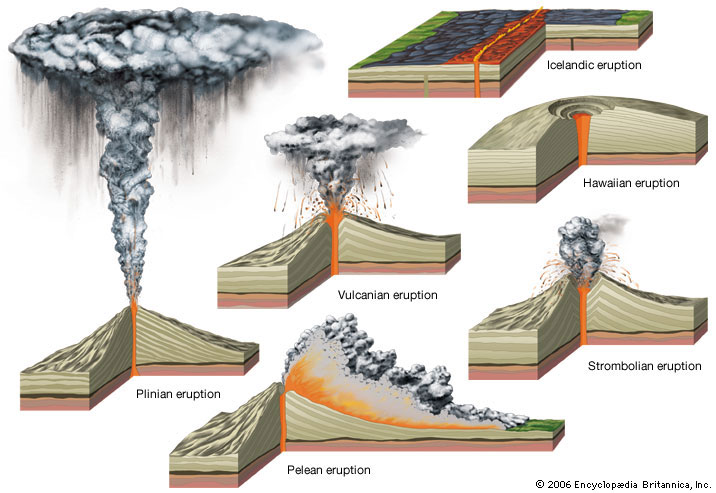
- Volcanic Eruption: Major Types
- Types of Volcanoes
| CASCADE RANGE VOLCANOES
Current Volcano Alert Level: all NORMAL Current Aviation Color Code: all GREEN |
| CVO Cascade Range GREEN/NORMAL - All volcanoes are at normal levels. |
| Apr 26, 2024 19:46 - Activity Update: All volcanoes in the Cascade Range of Oregon and Washington are at normal background activity levels. These include Mount Baker, Glacier Peak, Mount Rainier, Mount St. Helens, and Mount Adams in Washington State and Mount Hood, Mount Jefferson, Three Sisters, Newberry, and Crater Lake in Oregon.Past Week Observations: During the past week, small earthquakes were detected at Mount Hood, Mount St. Helens, and Mount Rainier. All monitoring data are consistent with background activity levels in the Cascades Range. [ More ] |
| Source: Cascade Range Current Update |
Mount St. Helens VolcanoCam |
Johnston Ridge Observatory Webcam (click for enlarge) |
|
This static image is from a USGS Cascades Volcano Observatory research camera located at the Johnston Ridge Observatory, north of Mount St. Helens.
The view is to the south. This camera is intended to assist the USGS with situational awareness. At times, clouds, rain, and snow obscure visibility.
Because this camera is located in a harsh environment, it may sporadically breakdown and go off-line for extended periods of time before repairs can be made.
The image refreshes every 5 minutes. Volcano image courtesy of ... |
| Information courtesy of ... U.S. Geological Survey, Vancouver, Washington University of Washington, Pacific Northwest Seismograph Network, Seattle, Washington
|


powered by Cumulus v1.9.3 (1059)
Ambient Weather VWS v14.00 Weather-Display (10.37S-(b58))
Virtual VP software Top Website Map Copyright © 2007 - 2024 Foresthillweather.com Never base important decisions on this or any weather information obtained from the Internet
Ambient Weather VWS v14.00 Weather-Display (10.37S-(b58))
Virtual VP software Top Website Map Copyright © 2007 - 2024 Foresthillweather.com Never base important decisions on this or any weather information obtained from the Internet