
- Home
- Forecast
- Radar
- Maps
- WX-Data
- WX-Misc.
- Astronomy
- Fire
- About
- Links
 Air Quality


")

| Advisories / Alerts |
| Severe Wx Summary! | ||||||||||||
 |
||||||||||||
|
||||||||||||
|
||||||||||||
 |
||||||||||||
| Wed, May 8, 2024 - 5:52pm | ||||||||||||
|
|
|
|
|
|
Info Links


| Secrets of the Maud Rise Polyna Revealed | |||
|
|||
May 8, 2024 |
|||
|
September 25, 2017 September 23, 2023 Tweet Share
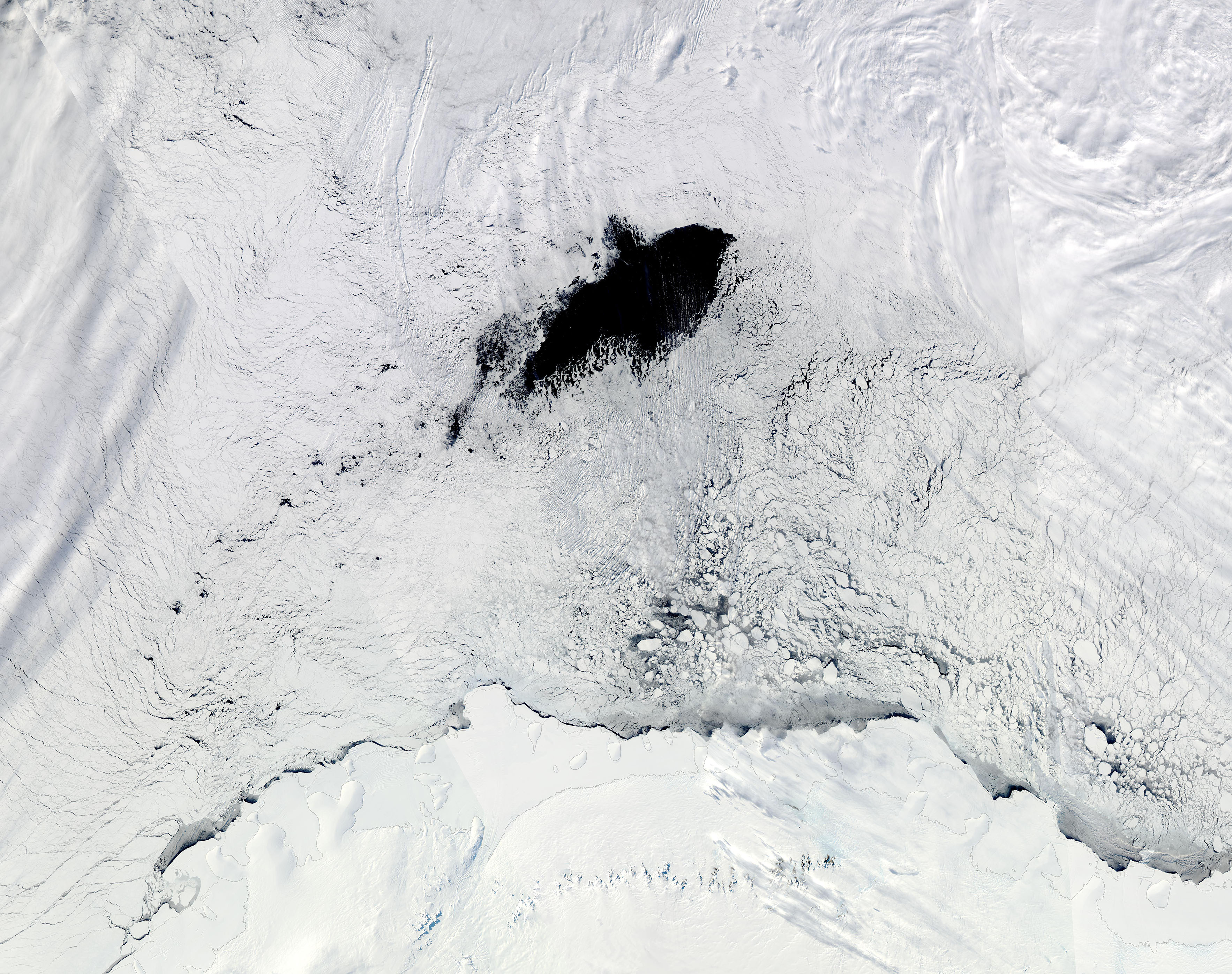
Each winter, the oceans around Antarctica become heavily encrusted with a thick layer of ice, thanks to frigid temperatures and short daylight hours. The vast expanse of ice, which spans an area roughly twice the size of the continental United States, isn’t perfectly smooth; sometimes cracks or openings form. A large area of open water that exposes the seawater underneath is called a polynya. They usually form close to shore, but more rarely form in a sheet of ice over the open ocean. For decades, scientists have been studying just how these state-sized gaps in otherwise solid ice are formed. It’s been clear that a combination of ocean current and wind play a role in polynya formation, but that never quite fully explained the formation of some particularly complex ones, such as the Maud Rise polynya, which appears only sporadically. The Maud Rise polynya surprised scientists when it appeared in satellite images in the 1970s. It was estimated to be about the size of Oregon when it was first discovered. Smaller versions appeared at the same site over the years, but in the winter of 2016-2017, it showed up as a truly massive gap in the ice—approximately the size of Switzerland—and it lasted for many weeks. Scientists got even more curious about just what mechanisms drove the formation of this particularly erratic polynya. On May 1, 2024, a team of scientists published a study in the journal “Science Advances” that helps explain both the formation and persistence of the Maud Rise polynya in 2016-2017. The factors included not only currents and wind, but also the mountain-like formation on the sea floor (known as the Maud Rise) under the polynya, which helped trigger a spiral-like movement of salt from the deeper layers of the ocean upward (“Eckman transport”). Normally, when sea ice melts, the water immediately beneath it becomes less saline, which in turn slows melting. But Eckman transport kept salt levels high at the polynya, which allowed melting to continue and slowed refreezing, creating a massive and long-lasting polynya. On September 25, 2017, the Moderate Resolution Imaging Spectroradiometer (MODIS) on NASA’s Aqua satellite acquired a true-color image of the huge Maud Rise polynya near its historically largest size. By clicking on the dates, this image can be compared with a second Aqua MODIS image acquired on September 23, 2023, which shows a more normal winter ice cover.
|
|||
| Image Facts Satellite: Aqua Date Acquired: 9/25/2017 Resolutions: 1km (655 KB), 500m (2.1 MB), 250m (5.6 MB) Bands Used: 1,4,3 Image Credit: MODIS Land Rapid Response Team, NASA GSFC |
|||
| Courtesy of NASA MODIS Website | |||


Ambient Weather VWS v14.00 Weather-Display (10.37S-(b58))
Virtual VP software Top Website Map Copyright © 2007 - 2024 Foresthillweather.com Never base important decisions on this or any weather information obtained from the Internet