
- Home
- Forecast
- Radar
- Maps
- WX-Data
- WX-Misc.
- Astronomy
- Fire
- About
- Links
 Air Quality
Space WX Alerts:
( Latest Alert ) - Issue Time: 2024 Apr 26 2300 UTC
EXTENDED WARNING: Geomagnetic K-index of 4 expected
| Weather Conditions Clear skies, Dry Visibility: 10 miles |
|
|
This Icon is a Combination of Blue Canyon Airport and Data From foresthillweather.com |
|
39.6°F
Calm
Updated:
4/27/24 5:41am

")

| Advisories / Alerts |
| Severe Wx Summary! | ||||||||
 |
||||||||
|
||||||||
|
||||||||
 |
||||||||
| Sat, Apr 27, 2024 - 5:31am | ||||||||
|
|
|
|
|
|
Info Links

National Weather Service - Severe Weather Summary
|
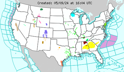
Latest U.S. Weather Alerts
 Click Map Region to Display Local Forecast Office Map Below
|
||
Weather Forecast Office
|
|
|


Local Warnings and Advisory Last Update: 4:57 am PDT Apr 27, 2024 |
6 Miles NE Yosemite CA 37.82°N 119.44°W (Elev. 9800 ft) |
There are no Warnings or Advisorys at this location at this time |
7 Day Forecast 6 Miles NE Yosemite CA 37.82°N 119.44°W (Elev. 9800 ft) |
||||||||
Today Increasing Clouds |
Tonight Partly Cloudy |
Sunday Sunny |
Sunday Night  Mostly Clear |
Monday Sunny |
Monday Night  Clear |
Tuesday Sunny |
Tuesday Night Clear |
Wednesday Sunny |
| Hi: 42 °F | Lo: 20 °F | Hi: 47 °F | Lo: 20 °F | Hi: 51 °F | Lo: 24 °F | Hi: 52 °F | Lo: 24 °F | Hi: 54 °F |
|
Today
Increasing clouds, with a high near 42. Wind chill values as low as 2. Northeast wind 10 to 15 mph becoming west northwest in the morning.
Tonight
Partly cloudy, with a low around 20. Wind chill values as low as 13. North wind 5 to 10 mph becoming west after midnight.
Sunday
Sunny, with a high near 47. Wind chill values as low as 13 early. Northwest wind 5 to 10 mph becoming west southwest in the morning.
Sunday Night
Mostly clear, with a low around 20. Wind chill values as low as 13. West wind 5 to 10 mph.
Monday
Sunny, with a high near 51. West wind 5 to 15 mph.
Monday Night
Clear, with a low around 24. West wind 5 to 10 mph becoming north in the evening. Winds could gust as high as 15 mph.
Tuesday
Sunny, with a high near 52. South southeast wind around 10 mph becoming west in the morning. Winds could gust as high as 15 mph.
Tuesday Night
Clear, with a low around 24. West wind around 10 mph becoming north in the evening. Winds could gust as high as 15 mph.
Wednesday
Sunny, with a high near 54. Southeast wind around 10 mph becoming west southwest in the morning. Winds could gust as high as 15 mph.
Wednesday Night
Mostly clear, with a low around 26. West southwest wind around 10 mph becoming east southeast in the evening. Winds could gust as high as 15 mph.
Thursday
Sunny, with a high near 51. West southwest wind 10 to 15 mph, with gusts as high as 20 mph.
Thursday Night
Mostly clear, with a low around 23. West southwest wind 10 to 15 mph becoming south in the evening. Winds could gust as high as 20 mph.
Friday
Sunny, with a high near 51. South wind 10 to 15 mph becoming west in the morning. Winds could gust as high as 20 mph.
|
|


powered by Cumulus v1.9.3 (1059)
Ambient Weather VWS v14.00 Weather-Display (10.37S-(b58))
Virtual VP software Top Website Map Copyright © 2007 - 2024 Foresthillweather.com Never base important decisions on this or any weather information obtained from the Internet
Ambient Weather VWS v14.00 Weather-Display (10.37S-(b58))
Virtual VP software Top Website Map Copyright © 2007 - 2024 Foresthillweather.com Never base important decisions on this or any weather information obtained from the Internet